

This information is added by users of ASN. Neither ASN nor the Flight Safety Foundation are responsible for the completeness or correctness of this information.
If you feel this information is incomplete or incorrect, you can submit corrected information.
| Date: | Saturday 19 February 2022 |
| Time: | 13:28 |
| Type: |  Van's RV-7A |
| Owner/operator: | Private |
| Registration: | N787NV |
| MSN: | 72097 |
| Year of manufacture: | 2019 |
| Fatalities: | Fatalities: 1 / Occupants: 1 |
| Other fatalities: | 0 |
| Aircraft damage: | Destroyed |
| Category: | Accident |
| Location: | near Triangle Airpark (AZ50), White Hills, AZ -
 United States of America United States of America
|
| Phase: | Manoeuvring (airshow, firefighting, ag.ops.) |
| Nature: | Private |
| Departure airport: | Boulder City Municipal Airport, NV (BLD/KBVU) |
| Triangle Airpark, AZ (AZ50) | |
| Investigating agency: | NTSB |
| Confidence Rating: |
On February 19, 2022, about 1328 mountain standard time, an experimental, amateur-built Vans RV-7A airplane, N787NV, was destroyed when it was involved in an accident near White Hills, Arizona. The pilot was fatally injured. The airplane was operated by the pilot as a Title 14 Code of Federal Regulations Part 91 personal flight.
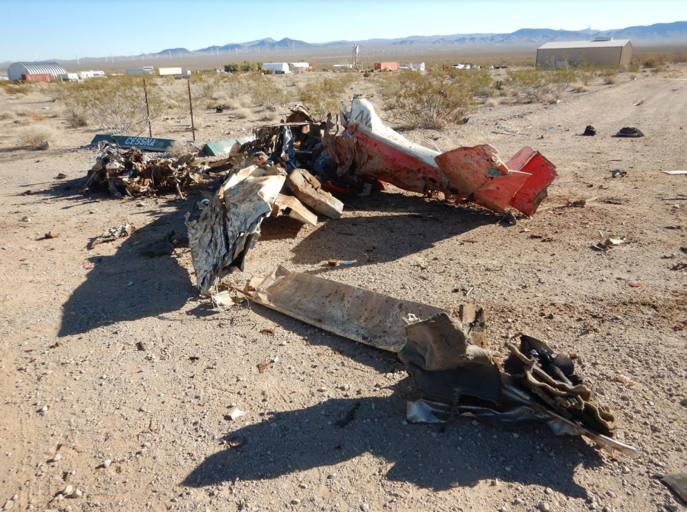
The pilot was conducting a personal flight in his experimental, amateur-built airplane. The flight data revealed that the pilot made multiple 90-degree turns before the airplane’s flight path became established over a highway. The airplane then entered a maneuver that was consistent with an aileron roll where it lost about 1,000 ft of altitude. A few minutes later the airplane entered a maneuver consistent with a split-S. Security video near the accident site captured the airplane in a steep nose-down descent before impacting the ground near airport hangars. Several objects from the airplane were seen falling to the ground south of the accident site. In another security video, an image of the airplane showed that the left horizontal stabilizer and elevator and the vertical stabilizer and rudder had separated from the empennage. A portion of the right horizontal stabilizer and elevator remained attached to the empennage. The left wing tip and canopy also separated. The accident site debris field revealed that the rudder and rudder surface skin were the furthest separated components from the impact crater and main wreckage, indicating that the rudder was likely the first component to fail. The remaining separated components were found in the debris field.
The airplane data revealed that the pilot entered the split-S maneuver at an airspeed that exceeded the published manufacturer’s airspeed for that maneuver. The airplane then rolled to an inverted position and pitched down causing the airspeed to increase dramatically. The last recorded data point, at an altitude about 3,199 ft, showed the airspeed was 248 KIAS (262 KTAS), well above the published never exceed speed of 200 knots. The high airspeed allowed rudder flutter to occur, resulting in an in-flight breakup and subsequent impact with terrain.
A postaccident examination of the airframe revealed damage consistent with an in-flight rudder flutter event that resulted in an in-flight breakup and subsequent impact with terrain.
There were no indications of any pre-existing cracks or anomalies with the airframe structures, and no pre-accident anomalies were observed that would have precluded normal control of the airplane.
Probable Cause: The pilot’s improper aerobatic maneuver leading to an airspeed that exceeded the airplane’s design limits, which resulted in rudder flutter and an in-flight breakup.
Accident investigation:
 |
|
Sources:
https://www.fox10phoenix.com/news/nevada-pilot-killed-in-northwestern-arizona-plane-crash
https://www.abc15.com/news/state/pilot-killed-in-plane-crash-northwest-of-kingman-saturday
https://data.ntsb.gov/Docket?ProjectID=104670
https://registry.faa.gov/AircraftInquiry/Search/NNumberResult?nNumberTxt=787NV
https://flightaware.com/live/flight/N787NV/history/20220219/2016Z/KBVU/AZ50
https://globe.adsbexchange.com/?icao=aaabc7&lat=35.775&lon=-114.631&zoom=11.0&showTrace=2022-02-19
https://www.airport-data.com/images/aircraft/001/505/001505948.jpg (photo)
Location
Images:

Photos: NTSB
Revision history:
| Date/time | Contributor | Updates |
|---|---|---|
| 20-Feb-2022 03:10 | Geno | Added |
| 20-Feb-2022 06:49 | harro | Updated [Aircraft type] |
| 20-Feb-2022 15:54 | RobertMB | Updated [Time, Aircraft type, Registration, Cn, Operator, Location, Phase, Nature, Departure airport, Destination airport, Source, Damage, Narrative] |
| 20-Feb-2022 18:03 | johnwg | Updated [Time, Source, Narrative, Category] |
| 17-Mar-2022 20:10 | Captain Adam | Updated [Location, Source, Narrative, Category] |
| 02-May-2024 20:18 | Captain Adam | Updated [Phase, Source, Narrative, Accident report, Photo] |
| 02-May-2024 20:21 | Captain Adam | Updated [Photo] |
Corrections or additions? ... Edit this accident description
The Aviation Safety Network is an exclusive service provided by:
Quick Links:
| ASN Home | Send Correction / Feedback |
| FSF Home | Disclaimer | Copyright |
| Contact Us | Privacy Policy |
| Press / Media |
 ©2024 Flight Safety Foundation