This information is added by users of ASN. Neither ASN nor the Flight Safety Foundation are responsible for the completeness or correctness of this information.
If you feel this information is incomplete or incorrect, you can submit corrected information.
| Date: | Friday 14 June 2002 |
| Time: | 20:35 |
| Type: |  Piper PA-46-310P Malibu |
| Owner/operator: | Private |
| Registration: | N9143B |
| MSN: | 4608134 |
| Year of manufacture: | 1988 |
| Total airframe hrs: | 2813 hours |
| Engine model: | Pratt & Whitney Canada PT6A-34 |
| Fatalities: | Fatalities: 3 / Occupants: 3 |
| Other fatalities: | 0 |
| Aircraft damage: | Destroyed |
| Category: | Accident |
| Location: | Osteen, FL -
 United States of America United States of America
|
| Phase: | Manoeuvring (airshow, firefighting, ag.ops.) |
| Nature: | Private |
| Departure airport: | Raleigh/Durham Airport, NC (RDU/KRDU) |
| Marco Island Airport, FL (MRK/KMKY) | |
| Investigating agency: | NTSB |
| Confidence Rating: |
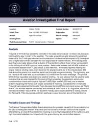
On June 14, 2002, about 2035 eastern daylight time, a Piper PA-46-310P, N9143B, operated and registered to an individual, had an in-flight separation of the right wing, and the left horizontal stabilizer, and impacted the ground about 8.5 miles northeast of Osteen, Florida. Instrument meteorological conditions prevailed at the time, and an instrument flight rules (IFR) flight plan was filed for the 14 CFR Part 91 personal flight. The airplane was destroyed. The private-rated pilot and two passengers were fatally injured. The flight had originated from Raleigh, North Carolina, that same day, about 1828, and was en route to Marco Island, Florida
The pilot of N9143B had asked the controller if he could deviate about 12 miles west, because he thought he saw "a hole" in the weather. The radar ground track plot showed the pilot had observed a 3 to 5 mile gap between two thunderstorm clusters and attempted to fly through an area of light radar echoes between the two large areas of heavier echoes. N9143B departed level flight, and radar showed that a cluster of thunderstorms, level three to four were present in the vicinity of N9143B's ground track position. Radar data showed that N9143B started an uncontrolled descent from FL260 (about 27,500 feet msl). Witnesses reported hearing the engine make a winding noise, then observed the airplane come out of the clouds about 300 feet above the ground, in a nose low spiral, and the right wing was missing. The right wing was not found at the crash site, but was located 1.62 miles from the main wreckage. The pilot of N9143B had requested and received a weather briefing. He was advised that the weather data indicated that an area forecast for his route of flight predicted thunderstorm activity and cumulonimbus clouds with tops as high as FL450 (flight level 45,000 feet), and a weather system impacting the Florida Gulf Coast, consisted of "looming thunderstorms" in that area. The pilot had contacted the Enroute Flight Advisory Service (EFAS, commonly known as "Flight Watch") for enroute weather advisories, and advised of "cells" east of St. Augustine, advised of convective SIGMET 05E in effect for southern Florida, and was advised that a routing toward the Tampa/St. Petersburg area and then southward, would avoid an area of thunderstorms.
Probable Cause: The pilot's inadequate weather evaluation and his failure to maintain control of the airplane after entering an area of thunderstorms resulting in an in-flight separation of the right wing and right horizontal stabilizer and impact with the ground during an uncontrolled descent.
Accident investigation:
 |
|
Sources:
NTSB: https://www.ntsb.gov/_layouts/ntsb.aviation/brief.aspx?ev_id=20020619X00932&key=1
Location
Images:

Photo: NTSB
Revision history:
| Date/time | Contributor | Updates |
|---|---|---|
| 28-Oct-2008 00:45 | ASN archive | Added |
| 21-Dec-2016 19:24 | ASN Update Bot | Updated [Time, Damage, Category, Investigating agency] |
| 09-Dec-2017 16:49 | ASN Update Bot | Updated [Source, Narrative] |
| 20-Dec-2023 19:40 | Captain Adam | Updated [Departure airport, Destination airport, Narrative, Accident report, Photo] |
Corrections or additions? ... Edit this accident description
The Aviation Safety Network is an exclusive service provided by:


 ©2024 Flight Safety Foundation